Monday, 24 July 2017

Day 50. Worth Matravers to South Haven Point


Just like yesterday's start I had to back track to get to where I had finished the previous day but I didn't mind as it was a fine morning and I'd had a good night.

Out on the cliff above Chapman's Pool I got the brilliant view that was obscured in yesterday's monsoon weather.

Houns-tout Cliff and Chapman's Pool

There's a theory that doing the south west coast path in the anti clockwise direction, like I have, is easier because the most difficult sections are in the first few weeks but I felt that these last two days were as difficult as any I had encountered, and that's after I'd been doing this for seven weeks.

Just before St Aldhelm's Head there was a valley to cross that was as deep and steep as any I'd come to.
Only 218 steps to the top

I had a rest on the bench at the top to admire the view and watch some Peregrine Falcons.

At St Aldhelm's Head I could see from the Isle of Portland in the west to the Isle of Wight in the east.

The National Coastwatch building on St Aldhelm's Head is apparently leased for 'one crab per annum if demanded'.

The path was much easier after the Head and went through a couple of old quarries.

Seacombe Quarry

It got very busy around Dancing Ledge with groups of youngsters enjoying kayaking, coasteering, climbing and hiking.

It's called Dancing Ledge because the flat rock between the cliff and the sea is roughly the size of a ballroom dance floor.

Durlston Head

I stopped for a while at Durlston Head to have a look at the map and decided I had enough time to finish the walk that day.

After Durlston Castle it was an easy slope down through woodland to the edge of Swanage.

Had a bite to eat at the Bull and Boat before walking along the beach and climbing steeply up to the chalk ridge with views back over Swanage.

Swanage Bay

As I walked through my last field of cows, up on the chalk ridge, the sun broke through the clouds and picked out the white cliffs on the Isle of Wight.

Isle of Wight in the distance

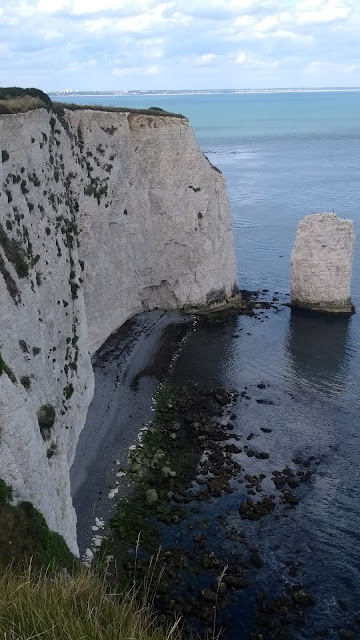
Old Harry Rocks

Old Harry Rocks

Old Harry Rocks

Studland Bay with Poole, and the finish, in the distance

I got onto the beach at the earliest opportunity at Studland to kick my smelly trainers off and walk along the water.

The sun was shining and the beach was hot.
I had only about a mile left to go so I treated myself to a refreshing dip on the stretch of beach where it doesn't matter if you have trunks or not.
It felt great.

Looking back to Old Harry Rocks

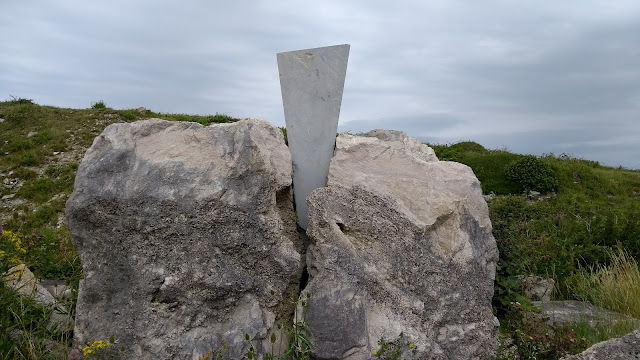
Just around the bend on the beach, there it was - The End !

It's a wonderful commemorative marker at the end (or beginning) of the walk but unfortunately it is positioned too close to the road to get a decent picture.
The queue of cars waiting for the ferry and the cars rapidly leaving the ferry were not going to wait while I found a willing passer by to take a snap of me next to it.


Had a few celebratory pints in the Shell Bay Bistro before pitching the tent on Bramble Bush Bay. (Don't tell the NT)

Bramble Bush Bay

A fitting end to a lovely day and a fantastic seven weeks.


Sunday, 23 July 2017

Day 49. Durdle Door to Worth Matravers

Had a slow start because I bumped into some friends staying on the site in their humungus motor home and then had to back track a bit from the campsite to get to where I left the path near Durdle Door.

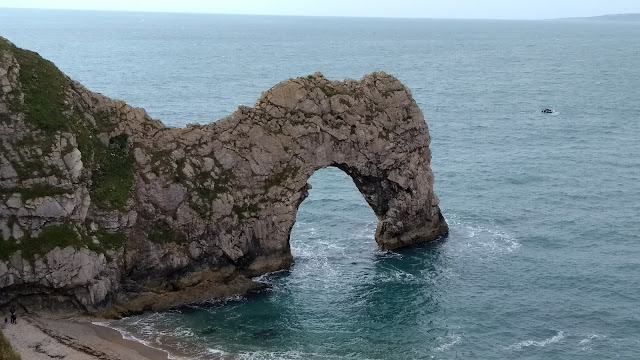
Durdle Door

It was Sunday and the area was very crowded with visitors of all nationalities.

Walking up the hill from Durdle Door I caught up with a couple of hikers that looked like they were on a bit of a mission.
We got chatting and they said that they were doing the Dorset Doddle; a walk that leaves Weymouth at 8am and aims to arrive in Swanage by 8pm.
That's about 35 miles with a cumulative ascent of about 6,600 feet.
Good to see that irony is alive and well in Dorset because that is definitely not a doddle.
They were the tail enders and I had my doubts that they were going to arrive by 8pm.

At Lulworth Cove I somehow passed the Lulworth Cove Inn without going in and followed the signs up to Stair Hole that looked popular with climbers and swimmers this morning.

Stair Hole

Went up further to get the view of the cove and followed the signs that went full circle back to the Inn.
Tried again but couldn't find a way out of the village and went past the Inn four times before eventually deciding to walk around the beach and climb up the other side.

Lulworth Cove

Lulworth Cove

Immediately after Lulworth Cove I came to the M.O.D. ranges that covered the next five miles or so.
The M.O.D. own a huge amount of property.
Fortunately the ranges are open to walk through at weekends in the summer so that saved a few miles of diversions.

There were some hefty climbs and a good view inland to Lulworth Castle and the venue for Camp Bestival.

Arish Mell and Halcombe Vale with the inevitable hill fort on the top


There had been a few showers but the big black clouds seemed to be mostly staying out at sea.
It was, however, getting very slippery on the steep descents.
Bindon Plantation

There were lots of information boards with interesting history about iron age settlements and how the military took possession of entire villages and hamlets and re-settled the residents.

Worbarrow Bay

Although I was getting hungry it was too wet to get the stove out and I had eaten my few bars and fruit so I was looking forward to Kimmeridge Bay where there would be refreshments.

Just before Kimmeridge Bay there was an oil well.
It sounds very grand but it's just one nodding donkey that produces about 80 barrels of oil a day from the shale and has been in operation since 1959.

Kimmeridge Bay and Clavell's Tower

The 'refreshments' at Kimmeridge Bay was actually just an ice cream van.
Had a look in the Marine Centre that was full of interesting stuff and had loads of information boards like this:


Climbed the steep hill up to Clavell's Tower where, apparently, Thomas Hardy used to go courting one of the local girls.
I thought there wouldn't have been much 'courting' happening after those climbs.
It was also the inspiration for PD James's book The Black Tower.

Jurassic

Those big black clouds that had been out at sea decided to move on to the land so the weather changed from showers to monsoon.

Might be in for a drop of rain

The steep, narrow, little paths soon turned into little rivers.
My trainers had worn quite smooth after 600 miles and couldn't get any grip at all on the Kimmeridge clay.
Once again it was my walking poles that saved the day.

170 slippery, wet steps down from Houns-tout Cliff

The deluge abated when I got to Chapman's Pool so I sat on a concrete block to wring out my socks and consider my options.
Camping was out of the question and Swanage was a further three hours or so I went inland to find accommodation in Worth Matravers and got very lucky at the Old Post Office.

Got cleaned up and went to the village pub knowing that I was probably too late for food.

But no - The Square and Compass was a proper pub where they made their own pies and were happy to heat them up and serve until closing time.

This was a great pub where they served real ale through a small hatch and the beer barrels were lined up on the floor.

The building had lots of character and loads of original features and also a fossil museum in a side room.
The beer was good too!

What a great way to end the day.


Saturday, 22 July 2017

Day 48. Weymouth to Durdle Door

Jo and Hannah dropped me off where I finished yesterday in Weymouth.
We said our goodbyes and I was going to be on my own from there to the finish.

Weymouth looked a lot better this morning and I was feeling a lot better too.

Walked along some well presented suburban roads around Belle Vue and through a tidy park to the impressive Nothe Fort.


I could have walked around the harbour but decided to take the little ferry across so I could savour the last ferry ride of the walk.

Weymouth Harbour from the little ferry

The town was very busy on this fine morning and was putting on its best face with bunting everywhere.

I went looking in vain for camping food supplies and had to duck into an iffy boozer when a sudden cloudburst struck.

Walking along the promenade half an hour later I was struck by another cloudburst but by the time I had got my rucksack off and waterproofs on it was too late.
I was wet but it had already stopped raining.

Bowleaze Cove had really milked the Jurassic tag.
Every building was Jurassic this or that and all the children's rides were Jurassic something or other.

The path away from Weymouth had been diverted a long way inland, since I had last walked there, and went through the site for the upcoming Osfest.

Weymouth Bay and the Isle of Portland

Managed to avoid the next cloudburst when I was in the Smugglers Inn at Osmington and then walked down to the beach that has unusual stones called Osmington Ooliths.

It was a lovely walk through the woods to Ringstead and then a long, steady climb up to the top of White Nothe where the views were amazing.

Looking over Bat's Hole and Lulworth Cove to St Aldhelm's Head

The map of this area looks like the contour lines were drawn by Spirograph (ask your parents), the way they sweep and swirl and sometimes merge together to form one thick brown line for the steep sections.


It started to get very busy near Durdle Door when I saw a sign for a campsite pointing inland and decided to stop and get a shower.

Stop sniggering

Scratchy Bottom was used as the location in the opening scene in the 1967 film Far From The Madding Crowd when Gabriel Oak's dog drives his sheep over the cliff.

I walked up Scratchy Bottom and although I could see the campsite I had to circle around several fields, lanes and a farm to get to the entrance.

Found a spot to put the tent up and had a rest despite the noisy neighbours.
Went to the clubhouse to get some phone power and listen to the live music; the couple on guitars doing covers had an uncanny knack of making every song sound the same.

What a coincidence; having previously heard the Devon snoring champ, the bloke in the next tent (I assume it was a bloke) was the Dorset snoring champion.

Lying awake I realised I only had about thirty miles left to finish the walk.


Friday, 21 July 2017

Day 47. Ferrybridge, Isle of Portland, Weymouth

I had thought long and hard about whether to walk around the island or simply cross the road at the Ferrybridge Inn and continue the coast path into Weymouth but the island is part of the 630 miles and the acorn must be followed.

The weather looked ominous when I got dropped off at Ferrybridge and set off along the A354 into the wind and under dark skies.

First impressions weren't very good as a lot of Chiswell seemed to be boarded up.

I also naively thought that I would be walking around the island at low level but was soon climbing steeply up and around the first of many quarries.

A diversion took me into Tout Quarry that has been changed into a sculpture park with over fifty works by leading artists including Antony Gormley.

Chiswell and the road to the mainland

One of the rock sculptures depicting the old quarrying methods

There followed another diversion through a trading estate and along the main road before getting back to the cliff.


The views were probably spectacular on a clear day but all that could be seen were the white horses in the sea far below.

The view inland was pretty forgettable and Weston was perhaps the ugliest town I have ever seen and Southwell business park was bleak concrete covered in barbed wire.

On a quiet stretch of path I disturbed a couple indulging in what my local swimming pool used to refer to as necking or heavy petting.

It was busy at Portland Bill, the southern tip of the island, and everyone rushed into the cafe when the rain started.

Portland Bill Lighthouse

The walk along the east side of the island also went through disused quarries but was a lot lower and more sheltered from the increasing winds.
The rain was getting heavier and there wasn't much to see.

Church Ope Cove

The path followed a disused railway for a couple of miles under the cliffs.

With my hood up and head down I missed a sign that turned the path up the cliff and tramped on, through thickening wet vegetation, for half a mile only to come to a dead end and have to turn back.

Up on the cliff top the path went around the walls of the young offenders institute, through more post industrial scrub land, past the prison and down through the housing estates of Fortuneswell.

Sorry Portland, but I have rarely been to such a bleak and unattractive place.
It may be better in more clement weather but there would still be an awful lot of neglected ground and an abundance of barbed wire.

The weather was foul and I was soaked through.
The wind was whipping across the exposed road back to the mainland.
I was so cold that my hands were numb and could barely operate the phone to ring for a lift back from Weymouth.

I'm glad I wasn't camping in that weather.


Thursday, 20 July 2017

Day 46. Burton Bradstock to Ferrybridge

Went along the start of Chesil Beach at first and alongside the nature reserve but it was hard going on the shingle so we turned off at West Bexington to take the inland route.

Chesil Beach

The nature reserve

The inland route follows the Hardy Way along the ridge with lots of iron age forts and great views inland and out to sea across the length of Chesil Beach.

I had walked this route before but the scenery was still breathtaking


 We dropped down into Abbotsbury for a bite to eat and a look around the pretty village.

All of Abbotsbury, and sixty square kilometres around it, is owned by one woman.
I would think she's kept busy on changeover day.

St Catherine's Chapel

Hannah liked the enormous tree in the grounds of the old monastery

Walked along another, smaller ridge and through lovely rolling farmland for a few miles after Abbotsbury and out to the Fleet; the lagoon behind Chesil Beach

The Fleet

It was a beautiful day and with a strong breeze on our backs, and no rucksacks on our backs, we made good progress along the Fleet, through some holiday parks and around yet more M.O.D. land.

Our pick up point, the Ferrybridge Inn, had shut down so the end of a good day's walking was slightly tarnished by walking up the main road to the pub in Wyke Regis.


Tuesday, 18 July 2017

Day 45. West Bay to Burton Beach

Had a few days off in Bridport to celebrate my birthday with family.
Walked back up Golden Cap.

Five out of sixteen braved the climb up Golden Cap

We also walked out the back of Bridport
to Symondsbury through Hell Lane.

Stone age carving in Hell Lane.
Sorry, stoner age.

The walk from West Bay was diverted away from the 'Reggie Perrin' beach and the 'Broadchurch' cliff following a recent landslip.
We went inland and through the golf course and holiday park to Hive Beach.
Didn't bump into Billy Bragg in Burton Bradstock and walked back to Bridport.

Easy Peasy!


Friday, 14 July 2017

Day 44. Axmouth to West Bay

Couldn't help a feeling of déjà vu as I walked out of town and climbed up the hill, past the golf course, out onto the cliffs and then an inland diversion.

Out on the cliff again and a first glimpse of the Isle of Portland way off to the east.

Looking back at Beer Head, the most westerly chalk cliffs.

But after that the scenery changed completely as I walked through an area known as Goat Island.
In 1839 about fifteen acres slipped towards the sea leaving a 180 ft deep chasm between the two cliffs.

These information boards explain it better than I can.


It felt strange to be walking close to the sea but not able to see it.
The path was very narrow in places and it was getting hot and humid so I sometimes felt like I was hacking through a jungle.

I didn't meet many people but a few I did meet would ask me how far was it to get out onto the cliffs because they felt claustrophobic in there.

After about five miles I was starting to feel it too and felt a bit of relief to get to the Undercliff nature reserve where the woodland opened out.

Some of the exposed chalk cliff

Somewhere along the way I crossed from Devon into Dorset and looked down a hill to Lyme Regis and the famous Cob

The town was looking at its best in the sunshine and was packed.
Stopped for lunch at the Rock House Inn but they weren't playing any rock, just the awful absolute 80's radio at ear splitting volume.

As it was low tide I was able to walk along the beach from Lyme Regis to Charmouth, saving a few miles of road walking where the coast path had crumbled into the sea.

Walked to the accompiment of hundreds of small hammers trying to break open the rocks to find Jurassic fossils.

Stopped for a rest at Charmouth beach next to the wonderfully named Soft Rock Cafe and a breather before the climbs ahead.

Looking up at Golden Cap

Had a long steady climb up to Golden Cap, the highest point on the south coast, where the views were brilliant on this fine evening and I had the peak to myself.

191m, 627 feet above sea level

West Bay in the distance


Seatown and Golden Cap

Thorncombe Beacon

Feeling pretty knackered by now I stopped for a pint at the Anchor Inn at Seatown, once home to notorious smugglers known as the Chideock Gang.

Thought I would have a refreshing shower and stay at the campsite at Seatown but, because this was the first Friday of the school holidays, it was full.

Same story at Eype and at West Bay so I pitched up on the cliff above West Bay with a fantastic view back along the coast.

Good Night